
�������: 1-14 ���鵽����������ѧ water����ؼ�¼14�� . ��ѯʱ��(0.375 ��)
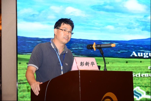
2017��ȫ������������ѧ��ˮ����Դ�ɳ�������ѧ�����ֻᡱ��International Workshop of Soil Physics and the Nexus of Food, Energy and Water Systems�������ٿ���ͼ��
2017�� ��������ѧ ˮ����Դ �ɳ������� ѧ�����ֻ� ����
2017/8/11
2017��8��3-6�գ����й�����ѧ����������רҵίԱ�����죬�й���ѧԺ����Ӧ����̬�о������й���ѧԺ��Ⱦ��̬�뻷�������ص�ʵ���ҡ�����ũҵ��ѧ������ʡũҵ��ѧԺ��������ѧ������ʡ����ѧ�ᡢ����ũ����̬ϵͳ����Ұ���ѧ�۲��о�վ���ϳа�ġ���������ѧ��ˮ����Դ�ɳ�������ѧ�����ֻᡱ��International Workshop of Soil Physics and the Nexus of ...
����������ѧ��ˮ����Դ����ѧ�����ֻᡱ��International Workshop of Soil Physics and the Nexus of Food, Energy and Water
��������ѧ��ˮ����Դ���� ���ֻ�
2017/5/3
����仯�������˿���������ʳ��ȫ����������ģʽ�ĸı�ʹ���������Ȼ��Դ�����IJ�������ͼ��٣����ŷŴ����к��������Ⱦ����ս����ٵ�ˮ����Դ��������ѹ��������������һЩ��ҪˮԴ�����غ���̬���ϵķ����ܡ�Ϊ���ƽ��ҹ���������ѧ�о�ȫ��ﵽ����ǰ��ˮƽ�ͼ�ǿ����ѧ��������������������ѧ�ڱ��Ϲ�����̬���������Ͱ�ȫ�е���Ҫ���ã��й�����ѧ����������ѧרҵίԱ�ᶨ��2017��8��3��5���������о�...
Predicting Oxidizable Carbon Content via Visible- and Near-Infrared Diffuse Reflectance Spectroscopy in Soils Heavily Affected by Water Erosion
Partial Least Squares Regression spectra pre-treatment
2015/7/28
Soil spectroscopy represents a low-cost alternative to routine time-consuming and expensive laboratory analyses.
Its ability to measure a wide range of different chemical and physical soil propertie...
Testing of activated carbon for water and non-volatile LNAPL quantitative determination in porous media under laboratory conditions
activated carbon LNAPL silica sand Silcarbon SC40 sampling interval
2015/3/10
Activated carbon is a highly porous form of carbon, which has an exceptionally large surface area. Activated carbon material has been artificially processed as a set of plates, within which two differ...
On parameterization of heat conduction in coupled soil water and heat flow modelling
advective heat flux dual-permeability model preferential flow soil heat transport soil thermal conductivity surface energy balance
2015/3/5
Soil water and heat transport plays an important role in various hydrologic, agricultural, and industrial applications. Accordingly, an increasing attention is paid to relevant simulation models. In t...
Comparison of two sensors ECH2O EC-5 and SM200 for measuring soil water content
bulk density CaCO3 ECH20 soil moisture sensor EC-5 fraction of sand particles SM200 sensor soil and soil water salinity soils of the Czech Republic soil water content
2015/3/3
The goal of this study was calibration of the ECH20 soil moisture sensor EC-5 and the sensor SM200 for selected soils of the Czech Republic. Based on the soil maps of the Czech Republic and various cl...
Variability of soil water-physical properties in a small catchment of the Loess Plateau, China
Geostatistical analysis regression analysis rainfall seasn land use pattern
2011/1/13
Data from the Donggou small catchment, located in a typical wind-water erosion crisscross zone on the Loess Plateau of China, illustrate the spatial variability of soil water-physical properties of di...
��ͬ��������ˮ���������ߵĿռ���켰��Ӱ�����أ�Spatial Variability of Soil Water Retention Curve in Different Soil Layers and Its Affecting Factors��
����ˮ���������� �ռ���� ���ط���
2010/1/28
���ö��ط��κ����϶��ط��η������������������0��20cm��20��40cm����van Genuchtenģ�Ͳ����Ŀռ�����Լ���Ӱ�����ؽ������о������������0��20cm��20��40cm������������������ԵĶ��ط����������ռ�����Խ�ǿ���ҷֱ����ɵ�ֵ��ֵ�ֲ�����ģ�����n�ͦ�s�Ķ��ط������������ԣ��ռ�����Խ�����0��20cm��20��40cm����van Genuchtenģ�Ͳ�����������������...
Spatial and Temporal Distribution of Soil Water Content in Fields under Different Vegetation Conditions Based on TDR Measurements
electromagnetic wave Andisol multiple probes with different lengths
2009/9/10
TDR (Time-domain reflectometry) is an advanced method for monitoring the water content in fields.TDR measurements can provide accurate information about vegetation effects on both spatial and temporal...
Water-Extraction by Split-Roots of Sesbania and Pigeon Pea Exposed to Spatially Heterogeneous Distribution of Soil Water
ABA Deep root Drought stress Groundwater Root distribution Specific root length Stomatal behaviour Water logging
2009/7/24
Previous studies have suggested that the deep roots of sesbania (Sesbania sesban) function less efficiently in water acquisition than those of pigeon pea (Cajanus cajan) despite similar rooting depths...
����������ˮ�����ʵ�ȿռ����������Է�����Determining Spatial Variability of Water Content and Hardness in Pastureland��
�����ݵ� ���� ��ˮ��
2009/5/22
��������ˮ��/Բָ�����ϲ���װ�ã�Ӧ�þ�ϸũ��������ϵ���������GPS��λ����һ�����Լ1.27hm2�IJݵ��ϻ�ȡ��������ˮ�����ʵ�ȿռ�ֲ��������ݣ�����Բ��������г��ֵ�����ȱʧ����ƫ��С���˷������ݽ�������Ȼ�����ÿ�����ֵ���������ֻ���ͼ�����ڴ˻����Ϸֱ�Ժ�ˮ�����ʵ�ȵĿռ�����Լ����ߵ���������˷�����
Mobilization of substances in peat soils and their transfer within the groundwater and into surface water
nitrogen compounds phosphate dissolved organic carbon peat soil groundwater surface water
2010/1/15
The behaviour of nitrate, ammonium, phosphate and dissolved organic carbon (DOC) in the system of groundwater and surface water at a peat soil site has been studied. Data were collected during 2000�C20...
Compare the Effect of Polluted and River Nile Irrigation Water on Contents of Heavy Metals of Some Soils and Plants
Irrigation water Pollution River Nile Soil Corn Heavy metals
2010/11/10
The objective of this study is to compare the effect of polluted in the El-Saff soils are irrigated from El-Khashab canal which is a mixture of domestic and industrial effluents and Nile water which i...
The impact of vegetation and soil parameters in simulations of surface energy and water balance in the semi-arid sahel: A case study using SEBEX and HAPEX-Sahel data
Semi-arid area Land parameters Model validation
2014/5/19
A series of numerical experiments has been designed to understand the physics at the land surface�Catmosphere interface in the Sahel and to find the major parameters and parameterizations that are cruc...
�й��о����������а�-��
- ���ڼ���...
�й�ѧ���ڿ����а�-��
- ���ڼ���...
�����ѧ���л������а�-��
- ���ڼ���...
�й���ѧ���а�-��
- ���ڼ���...
�ˡ���-ƪ
- ���ڼ���...
�Ρ���-ƪ
- ���ڼ���...
��������-ƪ
- ���ڼ���...
�������� -ƪ
- ���ڼ���...
֪ʶҪ��-ƪ
- ���ڼ���...
���ʶ�̬-ƪ
- ���ڼ���...
��������-ƪ
- ���ڼ���...
ѧ��ָ��-ƪ
- ���ڼ���...
ѧ��վ��-ƪ
- ���ڼ���...