搜索结果: 1-15 共查到“地图设计与编绘”相关记录123条 . 查询时间(4.406 秒)

自然资源部启用天地图二〇二〇版
自然资源部 天地图 二〇二〇版
2020/4/26
近日,自然资源部发布公告启用全国地理信息公共服务平台(天地图)2020版。新版本主要进行了数据更新和功能优化。在数据更新方面,新版天地图实现了全国31个省级节点、183个市级节点与国家级节点的数据融合;更新了2米分辨率遥感影像1000万平方千米,覆盖全部陆地国土;更新优于1米分辨率遥感影像537万平方千米,占陆地国土面积61%;更新了测绘地理信息资源目录81.9万条,累计发布517万条;提供了更新...
2011年北京师范大学地理学与遥感科学学院教师获得科研与教学成果奖励。

宋鹰,硕,博士生导师,副教授.1984年7月毕业于武汉测绘学院地图制图专业,获工学学士学位;2002年12月于武汉大学地图制图学与地理信息工程专业硕士研究生毕业,获工学硕士学位;2008年12月于武汉大学地图制图学与地理信息工程专业博士研究生毕业,获工学博士学位。1984年7月至1994年8月任山东省地图出版社编辑、编辑部副主任;1994年9月至1996年12月任山东师范大学地理研究所编辑;199...

华东师大地理信息科学教育部重点实验室创新作品《西北太平洋热带气旋气候图集(1981-2010)》日前斩获英国地图制图学会(British Cartographic Society)年度大奖——“John Bartholomew专题地图奖”和“Stanfords印制地图优质奖”。奖励旨在全方位表彰和宣传全球最佳的创新性制图设计和研究工作,是国际业界标志性重要奖项。图集副主编、地图总设计唐曦副教授受邀...
MAPPING RICE CROPPING SYSTEM IN THE LOWER GANGETIC PLAIN USING LANDASAT 8 (OLI) AND MODIS IMAGERY
Department of Geography and Environment Vidyasagar University Midnapore India
2019/2/27
The Indo-Gangetic basin is one of the productive rice growing areas in South-East Asia. Within this extensive flat fertile land, lower Gangetic basin, especially the south Bengal, is most intensively ...
山东大学科技期刊社四期刊获中国高校期刊奖励
山东大学科技期刊社 四期刊 中国高校 期刊奖励
2018/11/20
2018年11月5日,中国高校科技期刊研究会公布了2018年度全国高校“杰出·百佳·优秀科技期刊”评选结果。山东大学科技期刊社编辑出版的《山东大学学报(理学版)》被评为“中国高校百佳科技期刊”;《山东大学学报(医学版)》《山东大学学报(工学版)》《山东大学耳鼻喉眼学报》被评为“中国高校优秀科技期刊”。近年来,科技期刊社紧紧围绕学校“双一流”建设,以创建“名刊强社”为目标,认真谋划发展蓝图,实施“期...
山东大学2019年硕士研究生招生考试自命题设计创意考试大纲。

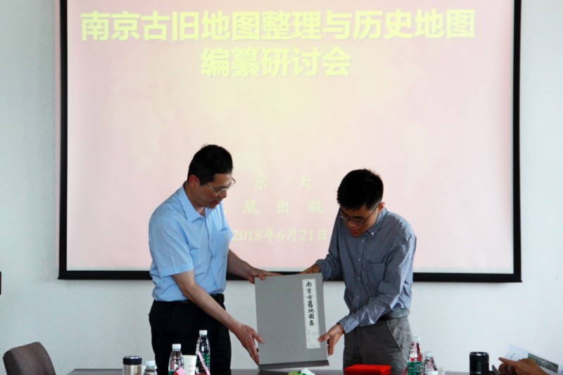
2018年6月20~21日,南京古旧地图整理与历史地图编纂研讨会在我校仙林校区昆山楼举行,来自北京大学、复旦大学、中国科学院大学、上海师范大学、厦门大学、台湾“中研院”、香港城市大学、宾夕法尼亚大学、南京大学、凤凰出版社、南京市博物总馆、南京市档案馆、南京市文广新局等学术机构、出版社和政府主管单位的三十多位专家学者与会。会议由历史学院副院长、《南京古旧地图集》(以下简称《图集》)主编胡阿祥教授主持...
为实现移动机器人环境探知并直观表现的功能,设计一种以前方180°为范围的简单几何地图绘制系统。该系统采用lpc1768 为核心,下位机部分以小型舵机MG90S 和超声模块HC-SR04 的云台组合为基础,上位机通过CVI 编写的程序对下位机测量的数据进行处理,将其通过上位机界面以二维地图形式直观表现;并通过探测3 种障碍地图进行验证。实验结果表明:该系统能准确反映机器人前方的环境信息,适用于移动机...
AUTOMATIC ROAD SIGN INVENTORY USING MOBILE MAPPING SYSTEMS
Mobile Mapping System Point cloud segmentation Road sign inventory Image processing Classification
2016/7/28
The periodic inspection of certain infrastructure features plays a key role for road network safety and preservation, and for developing optimal maintenance planning that minimize the life-cycle cost ...
FAST DRAWING OF TRAFFIC SIGN USING MOBILE MAPPING SYSTEM
Traffic Sign Fast Drawing Coarse Prediction Mobile Mapping System (MMS)
2016/7/28
Traffic sign provides road users with the specified instruction and information to enhance traffic safety. Automatic detection of traffic sign is important for navigation, autonomous driving, transpor...
Multi-image matching in object space on the basis of a general 3-D surface model instead of common 2.5-D surface models and its application for urban scenes
Surface Reconstruction Matching 3-d Surface Models Object Space
2016/5/23
A new method for high resolution surface reconstruction by multi-image matching in object space is formulated with regard to the integration of a general 3-d surface model in object space, because com...
Generation for 3D view map using polygon shift method
Polygon Shift Method bird’s eye view shadow depth distance
2016/5/20
The authors have developed a new method called "Polygon Shift Method" (named by the first author) that enables to generate bird's eye view of topographic landscape with shade and shadow. The Polygon S...
The design and development of a Geological Hypermap Prototype
design development Geological Hypermap Prototype
2016/5/20
A geologic map provides information about the currently accepted model regarding the subsurface structures in a given area. It is based on various types of information such as field observations, dril...


