
ЫбЫїНсЙћ: 46-60 ЙВВщЕНЁАЙЄбЇ LearningЁБЯрЙиМЧТМ408Ьѕ . ВщбЏЪБМф(0.171 Уы)
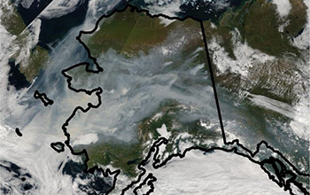
Researchers use machine learning to find out which wildfires will burn out of controlЃЈЭМЃЉ
machine learning social media University of California
2019/10/18
Scientists at the University of California, Irvine have developed a new technique for predicting the final size of a wildfire from the moment of ignition.Built around a machine learning algorithm, the...
ЩЯКЃВЦОДѓбЇаХЯЂЙмРэгыЙЄГЬбЇдКЪ§ОнЭкОђПЮМў Learning from Data
ЩЯКЃВЦОДѓбЇ аХЯЂЙмРэгыЙЄГЬбЇдК Ъ§ОнЭкОђ ПЮМў Learning from Data
2019/7/24
ЩЯКЃВЦОДѓбЇаХЯЂЙмРэгыЙЄГЬбЇдКЪ§ОнЭкОђПЮМў Learning from DataЁЃ

Dataset Bridges Human Vision and Machine LearningЃЈЭМЃЉ
Dataset Bridges Human Vision Machine Learning
2019/10/30
Neuroscientists and computer vision scientists say a new dataset of unprecedented size -- comprising functional brain scans of four volunteers who each viewed 5,000 images -- will help researchers bet...
TOWARDS DEEP LEARNING FOR ARCHITECTURE: A MONUMENT RECOGNITION MOBILE APP
Artificial Intelligence Machine Learning Deep Learning Convolutional Neural Networks
2019/3/4
In recent years, the diffusion of large image datasets and an unprecedented computational power have boosted the development of a class of artificial intelligence (AI) algorithms referred to as deep l...
MODEL FOR LAND COVER ESTIMATION USING UNSUPERVISED MACHINE LEARNING ON GOOGLE MAPS COLOR IMAGES
Unsupervised learning algorithms CORINE nomenclature Google Static Maps API k-means clustering
2019/2/27
Remote sensing data and satellite images are broadly used for land cover information. There are so many challenges to classify pixels on the basis of features and characteristics. Generally it is pixe...
MULTI-AGENT LEARNING FRAMEWORK FOR ENVIRONMENT REDUNDANCY IDENTIFICATION FOR MOBILE SENSORS IN AN IOT CONTEXT
Mutual information Gaussian Process Regression (GPR) multi-agent system mobile sensor networks IoT sensor planning
2018/11/9
From an IoT point of view, the continuous growth of cheap and versatile sensor technologies has generated a massive data flow in communication networks, which most of the time carries unnecessary or r...
VISIBLE ROUTES IN 3D DENSE CITY USING REINFORCEMENT LEARNING
3D GIS Visibility Routes Reinforcement learning
2018/11/9
In the last few years, the 3D GIS domain has developed rapidly, and has become increasingly accessible to different disciplines. 3D Spatial analysis of Built-up areas seems to be one of the most chall...
LINKDALE: A LIGHTWEIGHT LEARNING ENVIRONMENT FOR (GEOSPATIAL) LINKED DATA
Linked Data education earning environment reactjs visual linking
2018/11/8
Modern software tools for managing Linked Data are often designed for skilled users. Therefore, they cannot be used for education purposes because they require substantial a priori knowledge about the...
A COARSE-TO-FINE MODEL FOR AIRPLANE DETECTION FROM LARGE REMOTE SENSING IMAGES USING SALIENCY MODLE AND DEEP LEARNING
Airplane Detection Large-Scale Optical Remote Sensing Image Object of Interes Saliency Detection Single Neural Network
2018/5/15
High resolution remote sensing images are bearing the important strategic information, especially finding some time-sensitive-targets quickly, like airplanes, ships, and cars. Most of time the problem...
EXTRACTION OF BUILT-UP AREAS USING CONVOLUTIONAL NEURAL NETWORKS AND TRANSFER LEARNING FROM SENTINEL-2 SATELLITE IMAGES
Built-up Area Extraction Convolutional Neural Networks Deep Learning Sentinel-2 Images Transfer Learning
2018/5/11
With rapid globalization, the extent of built-up areas is continuously increasing. Extraction of features for classifying built-up areas that are more robust and abstract is a leading research topic f...
DETECTING WATER BODIES IN LANDSAT8 OLI IMAGE USING DEEP LEARNING
Water body Landsat Multi-layer perceptron Deep learning Maximum likelihood
2018/5/14
Water body identifying is critical to climate change, water resources, ecosystem service and hydrological cycle. Multi-layer perceptron(MLP) is the popular and classic method under deep learning frame...
APPLICATION OF CLASSIFICATION ALGORITHM OF MACHINE LEARNING AND BUFFER ANALYSIS IN TORISM REGIONAL PLANNING
the Chaohu Lake Land Use Classification Change Monitoring SVM Buffer Zone Analysis
2018/5/16
Remote Sensing (RS) and Geography Information System (GIS) technologies are widely used in ecological analysis and regional planning. With the advantages of large scale monitoring, combination of poin...
EXTRACTING 3D SEMANTIC INFORMATION FROM VIDEO SURVEILLANCE SYSTEM USING DEEP LEARNING
3-D space Camera calibration Target recognition Target tracking
2018/5/16
At present, intelligent video analysis technology has been widely used in various fields. Object tracking is one of the important part of intelligent video surveillance, but the traditional target tra...
RESEARCH ON HIGH ACCURACY DETECTION OF RED TIDE HYPERSPECRRAL BASED ON DEEP LEARNING CNN
Red Tide CNN Hyperspectral Remote Sensing Glint
2018/5/14
Increasing frequency in red tide outbreaks has been reported around the world. It is of great concern due to not only their adverse effects on human health and marine organisms, but also their impacts...
APPLICATION OF DEEP LEARNING IN GLOBELAND30-2010 PRODUCT REFINEMENT
GlobeLand30-2010 Deep learning Google Earth Training sample set High resolution images
2018/5/15
GlobeLand30, as one of the best Global Land Cover (GLC) product at 30-m resolution, has been widely used in many research fields. Due to the significant spectral confusion among different land cover t...
жаЙњбаОПЩњНЬг§ХХааАё-Ьѕ
- е§дкМгди...
жаЙњбЇЪѕЦкПЏХХааАё-Ьѕ
- е§дкМгди...
ЪРНчДѓбЇПЦбаЛњЙЙХХааАё-Ьѕ
- е§дкМгди...
жаЙњДѓбЇХХааАё-Ьѕ
- е§дкМгди...
ШЫЁЁЮя-ЦЊ
- е§дкМгди...
ПЮЁЁМў-ЦЊ
- е§дкМгди...
ЪгЬ§зЪСЯ-ЦЊ
- е§дкМгди...
баеазЪСЯ -ЦЊ
- е§дкМгди...
жЊЪЖвЊЮХ-ЦЊ
- е§дкМгди...
ЙњМЪЖЏЬЌ-ЦЊ
- е§дкМгди...
ЛсвщжааФ-ЦЊ
- е§дкМгди...
бЇЪѕжИФЯ-ЦЊ
- е§дкМгди...
бЇЪѕеОЕу-ЦЊ
- е§дкМгди...