搜索结果: 1-15 共查到“Canopy”相关记录182条 . 查询时间(0.077 秒)

南京农业大学农学院《IEEE Transactions on Geoscience and Remote Sensing》发表智慧农业团队“Quantify Wheat Canopy Leaf Angle Distribution Using Terrestrial Laser Scanning Data”(图)
智慧农业 智能解析 遗传育种
2024/6/11
作物表型高通量获取和智能解析为高效精准筛选优良种质资源提供技术支撑。2024年来,南京农业大学农学院智慧农业团队的作物表型监测组师生,利用地基激光雷达量化小麦冠层的叶角分布,取得了突破性进展。研究结果2024年4月4日以“Quantify Wheat Canopy Leaf Angle Distribution Using Terrestrial Laser Scanning Data”为题,发表...
Canopy Temperature Differences between Liana-Infested and Non-Liana Infested Areas in a Neotropical Dry Forest
lianas temperature difference thermal infrared remote sensing unmanned?aerial?vehicle?system tropical dry?forest
2024/1/23
Lianas (woody vines) are important non-structural elements of all tropical forests. Current field observations across the Neotropics suggest that liana abundance is rising as a result of?forest?distur...
Integrating LiDAR, Multispectral and SAR Data to Estimate and Map Canopy Height in Tropical Forests
ALOS-PALSAR dry tropical forest Landsat-8 learning algorithms moist tropical forest Sentinel-1 spatial modelling
2024/1/22
Developing accurate methods to map vegetation structure in tropical forests is essential to protect their biodiversity and improve their carbon stock estimation. We integrated LIDAR (Light Detection a...
Forests Growth Monitoring Based on Tree Canopy 3D Reconstruction Using UAV Aerial Photogrammetry
UAV aerial photography forest monitoring canopy 3D model
2024/1/22
Land cover monitoring is a major task for remote sensing. Compared to traditional methods of forests monitoring which mostly use orthophotography from satellites or aircraft, there is very little rese...
Democratic Republic of the Congo Tropical Forest Canopy Height and Aboveground Biomass Estimation with Landsat-8 Operational Land Imager (OLI) and Airborne LiDAR Data: The Effect of Seasonal Landsat Image Selection
Airborne LiDAR Landsat-8 tropical forest canopy height aboveground biomass Congo Basin Forest
2023/12/19
Inventories of tropical forest aboveground biomass (AGB) are often imprecise and sparse. Increasingly,?airborne?Light Detection And Ranging (LiDAR) and satellite optical wavelength sensor data are use...
Assessment of an improved individual tree detection method based on local-maximum algorithm from unmanned aerial vehicle RGB imagery in overlapping canopy mountain forests
CROWN DETECTION POINT CLOUDS UAV IMAGERY SEGMENTATION DELINEATION LIDAR INVENTORY HEIGHT FIELD
2023/12/15
Low consumer-grade cameras attached to small unmanned aerial vehicles (UAV) can easily acquire high spatial resolution images, leading to convenient forest monitoring at small-scales for forest manage...
Estimation of Surface Canopy Water in Pacific Northwest Forests by Fusing Radar, Lidar, and Meteorological Data
individual trees Sentinel-1 radar imagery time series Pacific Northwest
2023/12/6
Surface Canopy Water (SCW) is the intercepted rain water that resides within the tree canopy and plays a significant role in the hydrological cycle. Challenges arise in measuring?SCW?in remote areas u...
An Improved Generalized Hierarchical Estimation Framework with Geostatistics for Mapping Forest Parameters and Its Uncertainty: A Case Study of Forest Canopy Height
forest up-scaling regression kriging uncertainty LiDAR
2023/12/1
Forest canopy height is an essential parameter in estimating forest aboveground biomass (AGB), growing stock volume (GSV), and carbon storage, and it can provide necessary information in forest manage...
Unmanned?aerial?vehicles (UAV)-based canopy height modeling under leaf-on and leaf-off conditions for determining tree height and crown diameter (case study: Hyrcanian mixed?forest)
canopy height model digital elevation model forest inventory unmanned aerial vehicles (UAVs) tree crown architecture
2023/12/1
Tree height and crown diameter are two common individual tree attributes that can be estimated from unmanned aerial vehicle (UAV) images thanks to photogrammetry and structure from motion. This resear...
Stand Canopy Closure Estimation in Planted Forests Using a Geometric-Optical Model Based on Remote Sensing
canopy closure the GOST model fisheye camera photos transects LAI
2023/11/30
Canopy closure, which is the ratio of the vertical projection area of the crowns to the area of forest land, can indicate the growth and tending situation of a forest and is of great significance for ...

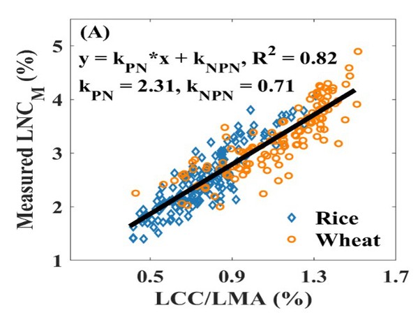
南京农业大学农学院《Remote Sensing of Environment》发表智慧农业团队“Estimating leaf nitrogen content by coupling a nitrogen allocation model with canopy reflectance”(图)
智慧农业 光谱监测 植物光合
2023/10/28
2022年11月1日,农学院智慧农业团队在国际顶级遥感期刊《Remote Sensing of Environment》发表了题为“Estimating leaf nitrogen content by coupling a nitrogen allocation model with canopy reflectance”的研究论文,报道了他们在冠层尺度氮含量光谱监测普适性模型构建方面的重要进展...
TREE CANOPY HEIGHT ESTIMATION USING MULTI BASELINE RVOG INVERSION TECHNIQUE
PolInSAR Tree Canopy Height Random Volume over Ground UAVSAR AfriSAR coherence
2019/2/28
Polarimetric Interferometric Synthetic Aperture Radar (PolInSAR) technique utilizes the characteristics of both SAR polarimetry and Interferometry. PolInSAR technique is proved to be very useful for v...
EVALUATION OF AIRBORNE L- BAND MULTI-BASELINE POL-INSAR FOR DEM EXTRACTION BENEATH FOREST CANOPY
Digital Elevation Model, SAR, Multi-baseline Pol-InSAR, TomoSAR, Forest canopy, Scattering characteristics separation
2018/5/14
DEM beneath forest canopy is difficult to extract with optical stereo pairs, InSAR and Pol-InSAR techniques. Tomographic SAR (TomoSAR) based on different penetration and view angles could reflect vert...
CANOPY MODELING OF AQUATIC VEGETATION: CONSTRUCTION OF SUBMERGED VEGETATION INDEX
Remote Sensing Submerged Vegetation Vegetation Index Radiative Transfer Model Sentinel-2A
2018/5/15
The unique spectral characteristics of submerged vegetation in wetlands determine that the conventional terrestrial vegetation index cannot be directly employed to species identification and parameter...
Estimation of diameter at breast height from mobile laser scanning data collected under a heavy forest canopy
mobile mapping system clustering point cloud circle fit
2018/3/6
Mobile laser scanning (MLS) is time-efficient technology of geospatial data collection that proved its ability to provide
accurate measurements in many fields. Mobile innovation of the terrestrial la...

