搜索结果: 1-15 共查到“工学 region”相关记录265条 . 查询时间(0.093 秒)

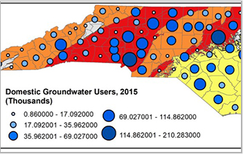
Piedmont region drinking wells exceed North Carolina's hexavalent chromium standards(图)
Piedmont region drinking wells North Carolina hexavalent chromium standards
2019/12/2
A new study that combines measurements from some 1,400 drinking water wells across North Carolina estimates that more than half the wells in the state's central region contain levels of cancer-causing...
DEFORMATION MONITORING IN AND AROUND THE NATIONAL CAPITAL REGION OF INDIA USING DINSAR TECHNIQUE
Sentinel-1 DInSAR Deformation NCR, Vasundra
2019/2/27
Urbanization increases the pressure on land and ground water. Due to pressure on land and over extraction of the ground water for modernization and development, deformation of land increase. The tradi...
COMPARISON OF SUPERVISED CLASSIFICATION TECHNIQUES WITH ALOS PALSAR SENSOR FOR ROORKEE REGION OF UTTARAKHAND, INDIA
Advanced land observing satellite PALSAR Supervised classification Kappa coefficient
2019/2/28
The Advanced Land Observing Satellite (ALOS) is developed by the Japanese Aerospace Exploration Agency (JAXA) which was launched in the year 2006 for the Earth observation and exploration purpose. The...
IDENTIFICATION OF IRON OXIDES MINERALS IN WESTERN JAHAJPUR REGION, INDIA USING AVIRIS-NG HYPERSPECTRAL REMOTE SENSING
AVIRIS-NG Iron-oxide Limonite Western Jahajpur belt Hyperspectral remote sensing
2019/2/27
Hyperspectral remote sensing is being considered as an advanced technique for mineral identification of surficial deposits. In this research different iron oxides minerals such as limonite, goethite h...
ECOLOGICAL SENSITIVITY EVALUATION OF TOURIST REGION BASED ON REMOTE SENSING IMAGE – TAKING CHAOHU LAKE AREA AS A CASE STUDY
image automatic classification analytic hierarchy process equal interval reclassification ecological sensitivity analysis
2018/5/15
Remote sensing technology is of significant advantages for monitoring and analysing ecological environment. By using of automatic extraction algorithm, various environmental resources information of t...
USING GIS FOR DEVELOPING SUSTAINABLE URBAN GROWTH CASE KYRENIA REGION
GIS MCE Sustainable Urban Growth Urban Analysis Kyrenia
2018/5/8
It is critical to develop urban layers for analysis sustainable urban development possibilities within planning process. Kyrenia Region has many physical, environmental or economic issues that may dan...
SEGMENTATION OF LARGE UNSTRUCTURED POINT CLOUDS USING OCTREE-BASED REGION GROWING AND CONDITIONAL RANDOM FIELDS
Segmentation Region Growing Conditional Random Fields Point Clouds
2018/3/5
Point cloud segmentation is a crucial step in scene understanding and interpretation. The goal is to decompose the initial data into sets of workable clusters with similar properties. Additionally, it...
Oil charging history and pathways of the Ordovician carbonate reservoir in the Tuoputai region, Tarim Basin, NW China
Oil population Oil charging events Fluid inclusion 1D numerical modeling Oil filling pathway
2018/4/2
Geochemical analysis of 64 oils sampled from an Ordovician carbonate reservoir in the Tuoputai region was undertaken to study the composition of molecular markers. All the oils have similar geochemica...
Learning Oriented Region-based Convolutional Neural Networks for Building Detection in Satellite Remote Sensing Images
VGG Building detection Deep learning OR-CNN Satellite remote sensing images
2017/7/13
The automated building detection in aerial images is a fundamental problem encountered in aerial and satellite images analysis. Recently, thanks to the advances in feature descriptions, Region-based C...
Effects of geo-ecological conditions on larch wood variations in the North European part of Russia (Arkhangelsk region)
Larix sibirica wood density latewood content ring width
2017/6/26
The present study examines the macrostructure and density of larch wood and possible influences on the productivity of larch stands. The studies were conducted in the middle and sub-tundra taiga in th...
Influence of droughts on remote villages in the karst region of Guizhou Province, China: Causes and control
Drought Karst Remote village Hazard prevention Water conservancy facilitiesSystem management
2018/3/23
Even though the precipitation is abundant in the Karst region of Guizhou Province, remote villages in this area frequently suffer severe droughts. This paper studied the causes of droughts in this reg...
USING LANDSAT 8 IMAGE TIME SERIES FOR CROP MAPPING IN A REGION OF CERRADO,BRAZIL
Crop mapping Landsat Time series Random Forest algorithm
2016/12/1
The objective of this research is to classify agricultural land use in a region of the Cerrado (Brazilian Savanna) biome using a time series of Enhanced Vegetation Index (EVI) from Landsat 8 OLI. Phen...
USING MULTI-CRITERIA ANALYSIS FOR THE STUDY OF HUMAN IMPACT ON AGRO-FORESTRY-PASTORAL ECOSYSTEM IN THE REGION OF KHENCHELA (ALGERIA)
Multi-criteria analysis human impacts ecosystem Khenchela
2016/11/30
The objective of this work is to study and analyze the human impact on agro-forestry-pastoral ecosystem of Khenchela region through the application of multi-criteria analysis methods to integrate geog...
LONG-TERM MONITORING OF WATER DYNAMICS IN THE SAHEL REGION USING THE MULTI-SAR-SYSTEM
SAR Geocoding Kennaugh Sahel Region Water Dynamics Long-term Monitoring
2016/11/30
Fresh water is a scarce resource in the West-African Sahel region, seasonally influenced by droughts and floods. Particularly in terms of climate change, the importance of wetlands increases for flora...
GEOSPATIAL ANALYSIS OF NEAR-SURFACE SOIL MOISTURE TIME SERIES DATA OVER INDIAN REGION
Geographic Information System (GIS) Soil Moisture Active and passive microwave remote sensing Drought Rainfall Long term trend
2016/11/23
The present study has developed the time series database surface soil moisture over India, for June, July and August months for the period of 20 years from 1991 to 2010, using data products generated ...

